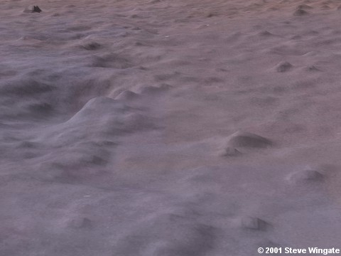
Ruins in Northern Acidalia Planitia
This image is cropped from M15-00835 labeled 'Cross
margin of seasonal N polar frost cap near Ls 350'. The location is 54.47° N
latitude, 15.56° W longitude, scale is 12.58 meters/pixel. The feature
is located about 900 km northwest of Cydonia. The image was taken at the end of the Martian winter.
For more data, see the MSSS
page for this image. Browser-viewable images on the MSSS page are reduced
in resolution compared to the images posted here.
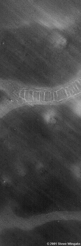 This
view, processed directly from the full resolution raw image, contains an
unusual feature which in many ways resembles ancient walls or possibly
the remaining walls of an ancient series of buildings. The features appear
to be raised above the surface rather than cracks caused by a fault or
other natural geological processes. The area surrounding the anomaly appears
to be either slanted upwards toward the top of the image (approximately
north) or a lighter area caused by some type of deposits, such as stones
that may have fallen from the walls or buildings. A second strip with out
the linear features can be seen in the lower part of this image. Could
this be a naturally occurring feature over which the walls may have been
built? Could there have been several areas interconnected as the next image
seems to suggest? In this case it is possible that some of the features
have been covered by dust or sand and have been partially uncovered in
one area. The streaks moving diagonally across the image suggest that prevailing
winds may be causing constant movement of sand, sometimes burying and other
times uncovering surface features.
This
view, processed directly from the full resolution raw image, contains an
unusual feature which in many ways resembles ancient walls or possibly
the remaining walls of an ancient series of buildings. The features appear
to be raised above the surface rather than cracks caused by a fault or
other natural geological processes. The area surrounding the anomaly appears
to be either slanted upwards toward the top of the image (approximately
north) or a lighter area caused by some type of deposits, such as stones
that may have fallen from the walls or buildings. A second strip with out
the linear features can be seen in the lower part of this image. Could
this be a naturally occurring feature over which the walls may have been
built? Could there have been several areas interconnected as the next image
seems to suggest? In this case it is possible that some of the features
have been covered by dust or sand and have been partially uncovered in
one area. The streaks moving diagonally across the image suggest that prevailing
winds may be causing constant movement of sand, sometimes burying and other
times uncovering surface features.
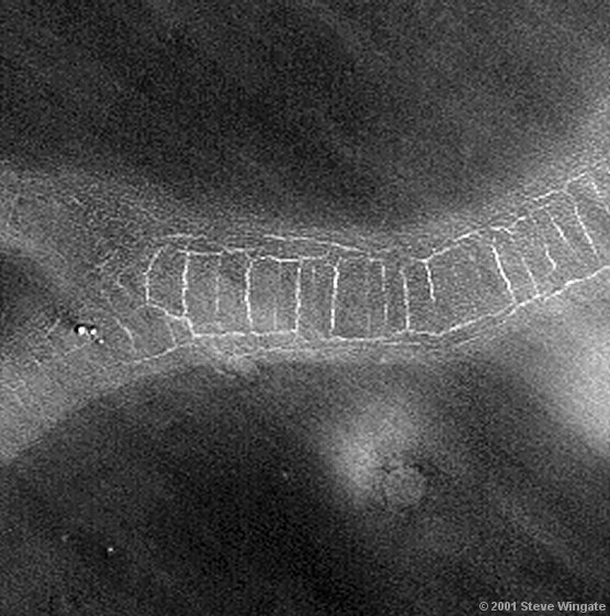 This
is a 2x enlargement which has also been sharpened and corrected for aspect
ratio. It shows that the possible structure may have had hallways and doorways
as well as revealing more subtle details of the surface. It can be seen
that while parts of the structure may have fallen down the walls of the
'cells' are remarkably parallel and straight in many cases. The scale of
this feature is quite large; for example the central cell is about
360 meters vertically in this image. Click
here for a comparison image showing the feature to the south in the
image above.
This
is a 2x enlargement which has also been sharpened and corrected for aspect
ratio. It shows that the possible structure may have had hallways and doorways
as well as revealing more subtle details of the surface. It can be seen
that while parts of the structure may have fallen down the walls of the
'cells' are remarkably parallel and straight in many cases. The scale of
this feature is quite large; for example the central cell is about
360 meters vertically in this image. Click
here for a comparison image showing the feature to the south in the
image above.
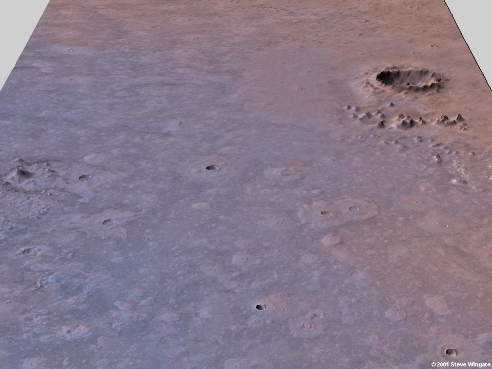
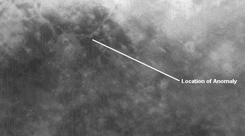 This
image processed from the raw context image shows the location of the anomalous
feature. The feature appears to be part of a network consisiting strips
of lighter-colored material. The area directly borders the ejecta blanket
of a nearby crater to the right. This is most apparent in the extreme right
of the image. The vertical bands are the remnants of stripes from the MGS
camera not removed completely by the destriping filter.
This
image processed from the raw context image shows the location of the anomalous
feature. The feature appears to be part of a network consisiting strips
of lighter-colored material. The area directly borders the ejecta blanket
of a nearby crater to the right. This is most apparent in the extreme right
of the image. The vertical bands are the remnants of stripes from the MGS
camera not removed completely by the destriping filter.
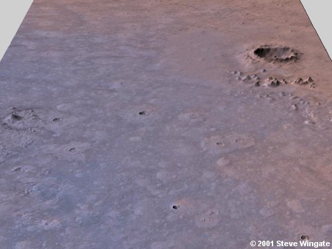 This
is a 3d northward-facing context image I rendered on Bryce with 1/32 degree
MOLA data and a texture from a colorization of a high resolution map with
a color map from Viking. The anomaly is located in the center of the image
bordering the western edge of the ejecta blanket from the large crater.
A moderate degree of vertical exaggeration was added to emphasize
the features of the topography. Click on image for a larger view.
This
is a 3d northward-facing context image I rendered on Bryce with 1/32 degree
MOLA data and a texture from a colorization of a high resolution map with
a color map from Viking. The anomaly is located in the center of the image
bordering the western edge of the ejecta blanket from the large crater.
A moderate degree of vertical exaggeration was added to emphasize
the features of the topography. Click on image for a larger view.
 This
is a closeup view of the anomaly area with a high vertical exaggeration
added to emphasize local topographical features. The anomaly is located
in the approximate center of the image. Click on image for a larger view.
This
is a closeup view of the anomaly area with a high vertical exaggeration
added to emphasize local topographical features. The anomaly is located
in the approximate center of the image. Click on image for a larger view.
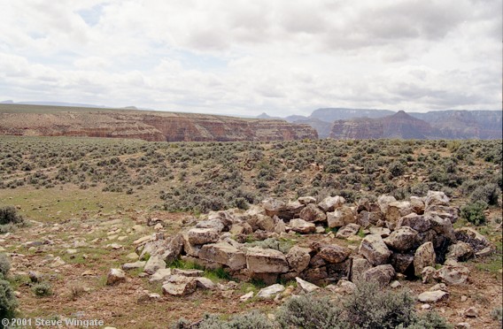 This
is a photograph from a recent trip to Arizona of the ruin of a hogan on
the Navajo Reservation above the Grand Canyon not far from where a secret
cave may lie below.
This
is a photograph from a recent trip to Arizona of the ruin of a hogan on
the Navajo Reservation above the Grand Canyon not far from where a secret
cave may lie below.
All images above Copyright 2001 Steve Wingate and Anomalous
Images. All rights reserved.
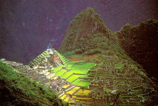 This
is a photograph Maccu Piccu in Peru. A simpler but massive ruin, when viewed
from above, might resemble the previous images in many ways, especially
when partially covered by sand or dust.
This
is a photograph Maccu Piccu in Peru. A simpler but massive ruin, when viewed
from above, might resemble the previous images in many ways, especially
when partially covered by sand or dust.
You are visitor number
since July 21, 2001
Return to Home Page

 This
is a 3d northward-facing context image I rendered on Bryce with 1/32 degree
MOLA data and a texture from a colorization of a high resolution map with
a color map from Viking. The anomaly is located in the center of the image
bordering the western edge of the ejecta blanket from the large crater.
A moderate degree of vertical exaggeration was added to emphasize
the features of the topography. Click on image for a larger view.
This
is a 3d northward-facing context image I rendered on Bryce with 1/32 degree
MOLA data and a texture from a colorization of a high resolution map with
a color map from Viking. The anomaly is located in the center of the image
bordering the western edge of the ejecta blanket from the large crater.
A moderate degree of vertical exaggeration was added to emphasize
the features of the topography. Click on image for a larger view.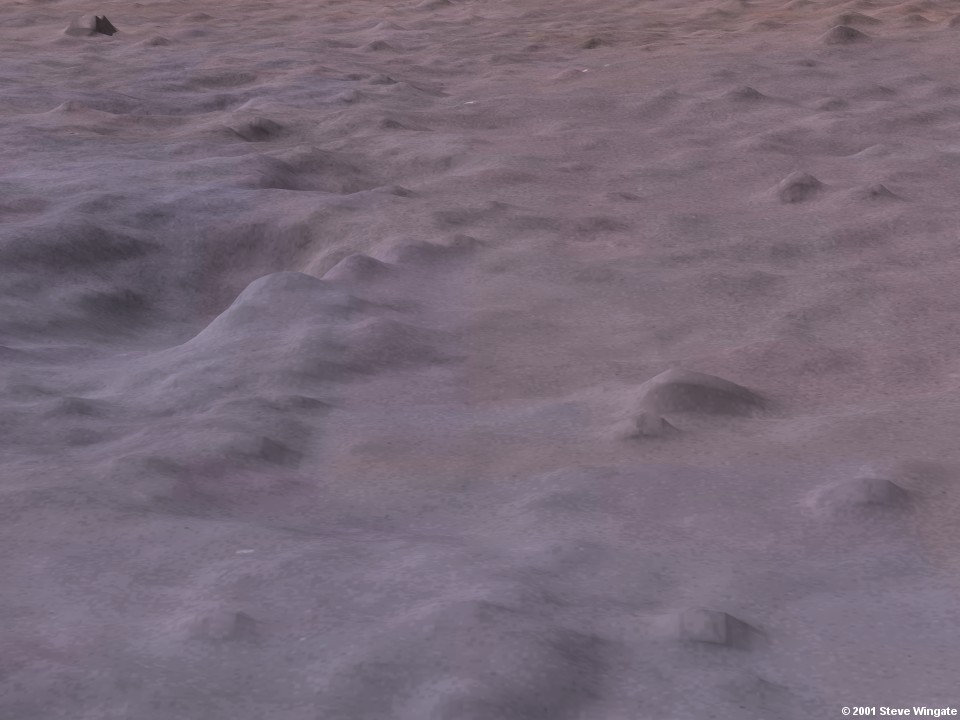 This
is a closeup view of the anomaly area with a high vertical exaggeration
added to emphasize local topographical features. The anomaly is located
in the approximate center of the image. Click on image for a larger view.
This
is a closeup view of the anomaly area with a high vertical exaggeration
added to emphasize local topographical features. The anomaly is located
in the approximate center of the image. Click on image for a larger view.