 Photos
 Maps
Maps Weather
 Flora
Flora Links
Links Index
Index Contact
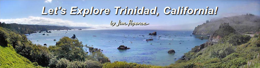
Let's Explore Trinidad, California!

Note: This web site has moved to a new address: trinidad.jimpopenoe.net. Please update your bookmark, as this page is no longer being updated, and it will be removed soon.
Trinidad, California is a small town on California’s north coast. Much of the Trinidad area is well above the ocean on marine terraces bordered by rugged sea cliffs. Above, we look south from the bluff along Edwards Street. On the left is the Scenic Drive coast. On the right are Trinidad Harbor and Trinidad Head. Trinidad’s natural setting is complemented by an extensive trail system for public enjoyment. You can use my Trinidad Trails Map as a guide.
The Axel Lindgren Trail leads down from Edwards Street to Old Home Beach. As we walk east on Old Home Beach, we cross two small creeks past basking harbor seals, and come to the Parker Creek Trail back up to town. Returning by this route, we can explore more of Trinidad and loop back to our starting point. Turn left at the top of the steps onto the Wagner Street Trail. Walk past the climbing roses along the bluff, and exit onto Wagner Street.
If it is low tide, we can continue east past Old Home Beach and scramble over rocks to pebbly He-Woli Beach. He-Woli Beach is the farthest we can go this way. A high, rocky point blocks further progress. We would have to take the Groth Lane Trail up to Scenic Drive to skirt around the point.
Walking west on Old Home Beach from the bottom of the Axel Lindgren Trail, we come to a jumble of boulders. Launcher Beach is on the opposite side. I only try to cross at low tide. The wet rocks are slippery, and others are rough with sharp edges. I stow all my gear in a pack to keep my hands free, and I wear leather gloves for protection. Atop the boulders we can enjoy close-up views of Trinidad Bay, Trinidad Head, Launcher Beach and Old Home Beach. The only sound is small waves lapping.
The Harbor Trail used to be a nice walk from town down to the harbor area. The trail makes a gradual descent along Van Wycke and Galindo Streets with benches at vista points along the way. Unfortunately, a landslide presently makes the path hazardous. To get around the slide, walk down Edwards Street and turn left onto Galindo Street. Launcher Beach is on the left at the bottom of the steps. Launcher Beach is so-named because small boats and kayaks launch here. Next to Little Head at the west end of Launcher Beach is a rail launch for larger boats. Beyond the launch is the Trinidad Pier. And if you turn right at the base of the steps, you can walk to Trinidad Head and Trinidad Beach. Trinidad's trails are all well connected for walking. But you can also drive down and park on the waterfront to explore these places.
The Trinidad Head loop trail has views in every direction. It is a 350-foot vertical climb, but well worth the effort. Allow about an hour for this hike. My Trinidad Head map details what you can see from the trail.
Along Scenic Drive are many small beaches and coves, sea stacks, and rocky bluffs with spectacular vistas. Trails lead down to Luffenholtz and Baker Beaches, and out to Houda and Tepona Points. My Scenic Drive map shows just where.
Trinidad State Beach is a recreation area that adjoins Trinidad on the north side of town. See my Trinidad State Beach map. The entire State Beach is accessible on foot from town, but it has two parking lots of its own. At the southern parking lot is an open grassy area with picnic tables and a restroom. A path leads down to Trinidad Beach at the mouth of Mill Creek, with views of Pewetole Island along the way. Trinidad Beach is a wonder to explore at low tide. See reflections of Pewetole and Trinidad Head in the wet sand. Look up at the towering, jagged rocks. Walk to the sea arch. Study the abundant intertidal life.
A 0.9-mile trail connects the southern and northern parking lots, and unifies the State Beach trail network. The south end of the connector trail follows the Mill Creek canyon under a mix of red alder, Sitka spruce and big-leaf maple. The air is moist and full of the sound of rushing water. A dense understory of ferns protects the steep slopes. Please be sure everyone stays on the trail to guard these fragile slopes from erosion. To fully enjoy the canyon, walk the trail at different times of year. Mill Creek can be a torrent in winter, but diminishes to a trickle by the end of summer. And around the bridge over Mill Creek, the look of the woods changes with the seasons.
North of Mill Creek, the connector trail ascends to a marine terrace. It is nearly level, and the forest is mainly Sitka spruce. The trail drops once more as we cross a bridge over College Cove Creek, and up again, 480 feet to the northern parking lot.
From the northern parking lot, we can take the Elk Head Trail west toward Elk Head. The trail is on a nearly level marine terrace. The vegetation is alder forest with red elderberry and a few Sitka spruce.
About 800 feet past the trailhead is a fork to the left. Steps descend steeply about 120 vertical feet from the bluff down to College Cove Beach. There is a small waterfall where College Cove Creek empties onto College Cove Beach.
Continuing west on the Elk Head Trail past the College Cove Trail, we can stop all along the bluff to enjoy views of College Cove, Pewetole Island and Trinidad Head. The trail forking to the right is a shortcut to Megwil Point. It goes through deeply shaded spruce forest. Let's keep left. The vegetation opens into coastal scrub as we come to a botanical area on Elk Head. There are ocean vista points as the trail turns northwest along the bluff. Eventually the trail begins a gentle descent, ending in steps at Megwil Point.
 Patrick's Point State Park, 10 minutes north of Trinidad, is a big favorite.
Great trails and views! Lots to see and do for kids of all ages!
Patrick's Point State Park, 10 minutes north of Trinidad, is a big favorite.
Great trails and views! Lots to see and do for kids of all ages!
 Big Lagoon, 15 minutes north of Trinidad, is fun for wading, agate
hunting, fishing, kayaking, sailing, windsurfing and birdwatching.
Big Lagoon, 15 minutes north of Trinidad, is fun for wading, agate
hunting, fishing, kayaking, sailing, windsurfing and birdwatching.
The redwood parks near Orick are just 25 minutes north of Trinidad. Simply
majestic... Allow plenty of time to explore the redwoods, too.
Other photos and information
I enjoy shooting 360° (spherical) panoramas.
I post my panoramas on the Roundme website, as well as
on Google. I list the Google-hosted panoramas, together with 360° panorama maps, on my
index page.
The California's Redwood Coast
website describes more ways to explore and to enjoy Trinidad. It is a
valuable reference whether or not you are exploring Trinidad for the first time.
J. Scott Shannon has compiled a photo history of Trinidad, California.
Be sure to download and print the BLM's free
California Coastal National Monument Trinidad Gateway Brochure. It tells about Trinidad's cultural history
and marine life, and it has a map of the very best places on the shoreline to explore.
Please see the Greater Trinidad Chamber of Commerce
website for information on events, lodging and other services.
Images by Jim Popenoe