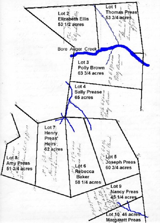
Division of Elizbeth Preas' Land - 15 July 1832
Bedford County, Virginia
**Elizabeth Preas, widow of Henry Preas Sr., was the matriarch of the Preas Family.
When she died, her land was divided amongst her children & heirs by lottery. Below,
you will find a map of her land divided into 10 different lotts and, following it, you will
find the names and description of the borders of each section. Questions? jrpreas@suddenlink.net
1832 July 15 --- Agreeable to the request of the Legaters of Elizabeth Preas Deceased we have proceeded(?)
to lay off & divide the lands of said decendant between the several Legatees as presented by the annexed platt(?) Vig,
Lott no. 1st ---- Drawn by Thomas Prease containing 53 3/4 acres and Bounded as follows Vig(?), Beginning at his
own corner white oak on the North side of Bore Augher Creek, thence a new line N80 (degrees) W 22 1/2 poles to said
creek Thence up the said creek as it meanders to a maple Thence off a new line N1 1/2 W 8 Poles to a stone and
pointers in the patent line thence along the patent line S88 1/5 (degree) E88 poles to pointers near a road thence along his
own line it being the patent line afour said S5 (degree) E 109 poles to the first station ----
Lott No. 2 - Drawn by Elizabeth Ellis containing 53 1/2 acres and bounded as follows VIG. Beginning at a Maple
and Bore Auger Creek bounded(?) to Lott No. 1 Thence up the creek as it meaders S77 1/2 (degrees) W 52 poles to
pointers in the patent line thence along the patent line N12 (degrees) E 14 poles to pointers on a hill N47 3/4 (degrees)
W 12 g to pointers called for by the patent in Wattons(?) line thence S 88 1/2 E145 poles to Rock and pointers near a
branch corner to Lott No 1. Thence along the line of said Lott S 11 (degrees) E 88 poles to the firest Station ----
Lott No 3. Drawn by Polly Brown containing 68 3/4 acres and bounded as follows Vig-Beginning at pointers on
Bore Auger Creek in the patent line and corner to Lott No 2 thence along the patent line S 12 (degrees) W 60 poles to
Rock & pointers in saind line Thence a need(?) line S 80 (degrees) E 154 poles to pointers on Thomas Preas s line
being the old patent line thence along the same N 7 (degrees) E 75 poles croping the creek to a white oak corner to Lott
No 1 Thence along the line of said Lott N 80 (degrees) W 22 1/2 poles to pointers on the creek aforesaid, thence up the
same as it meanders to the first Station -----
Lott No 4 ---- Drawn by Sally Prease containing 65 acres and bounded as follows Vig. Beginning at a rock and
pointers in the patent line & corner to Lott No. 3 Thence along the patent line S 12 (degrees) W 91(?) 1/2 poles to a
beach(?) at a branch thence a new line S 83 3/4 E 110 poles to pointers corner to the patent lines N 72 3/4 (degrees) E 56
poles to a dead Spanish Oak & pointers N 7(?) degrees E 45 poles to pointers corner to Lott No 3. Thence along the line
of saind Lott N 80 (degrees) W 154 poles to the first Station ------
to the patent & Lott No 4 thence along the patenet lines S 24 3/4 E up the mountain 89 poles to a white oak on a ridge
N 51 1/2(degrees) E 4 3/4 poles to pointers corner to Jeters. Thence along his line it being the patent line S 1 1/9 (degrees)
E 37 1/2 poles to pointers in sid line. Thence next(?) dividing lines - S 73 3/4 (degrees) N 761/2 poles to pointers N(?) 12 1/2
(degrees) W 149 poles to pointers in a line of Lott No. 4 thence along the line of said Lott S 83 3/4 (degrees) E 64 1/2 poles
to the first Station----
line of Lott No. 4 and corner to Lott No. 5 on a hill side thence along the line of Lott No. 5 S 12 1/2 (degrees) E 149 1/2
poles to pointers corner to Lott No 5 thence a new line S 73 3/4 W 77 1/2 poles to a large Red Oak on the Mountain &
corner to the patent. Thence a new line N172 1/2 poles to a Beach(?) corner to the patent to Lott No 4 Thence along the
line of said Lott S 83 3/4 E 45 1/2 poles to the first station -----
branch corner to the patent and to Lott No 4 & 6 thence along the patent line S 83 3/4 (degrees) W 57 3/4 poles to a large Red
Oak Stump Corner(?) to the patent. Thence a new line S 6 (degrees) W 136 poles to a Poplar & Soracl(?) at the North Side of
the mountain in the patent line thence S 66 3/4 (degrees) E 77 poles to a large Red oak on the mountain corner to the patent to
Lott No. 6 thence along the line of said Lott N 172 1/2 poles to the beginning-----
Lott No 8 -- Drawn by Amy Prease containing 51 3/4 acres and Bounded as follows Viz. Beginning at a Red oak stump
corner to the patent & to Lott No. 7 thence along the patent lines N 47 (degrees) W 57 1/2 poles to pointers corner (?) Sinclair
thence along his lines S 24 (degrees) W 21 1/2 poles to Spanish Oak S 15 (degrees) E 49 poles to pointers S 66 (degrees)
W 29 1/2 poles to chesnut(?) S 66 3/4 (degrees E 75 1/2 poles to a poplar & Sorsel(?) corner to Lott No 7 thence along the
line of said Lott N 6 (degrees) E 136 poles to the first station----
Lott No 9. --- Drawn by Nancy Prease containing 45 1/4 acres & bounded as follows - Beginning at a Large Red Oak at the
Mountain cornter to the patent in said line. Thence along the line of the patent S 37 1/4 (degrees) E 60 1/4 poles to pointers in
said line. Thence a new line N 69 (degrees) E 125 1/9 poles to pointers in Jeters line being the patent line thence along the same
N 1/2 W 49 poles to pointers corner to Lott No. 5 thence along the line of said Lott and passing(?) the corner of said Lott &
along the line of Lott No. 6 S 73 1/4 (degrees) W 154 poles to the first station ----
Lott no 10 --- Drawn by Margarett Prease containing 45 1/4 acres and bounded as follows viz. Beginning at pointers in the
patent line corner to Lott No. 9 thence along the patent lines S 37 1/4 (degrees) E 73 poles to a small white oak on a ridge
N 77 1/4 (degrees) E 74 1/2 poles to Jones corner Sreast(?) thence alnog his line N 1 1/9 (degrees) W 85 1/9 poles croping a
branch to pointers corner to Lott No. 9 thence along the line of said Lott S 69 (degrees) W 135 1/9 poles to the first Station ---
Having been called upon by the Legatees of Elizabeth Prease Deed, to lay off & allott all the lands of said decedant
between the aforesaid Legatees which according to the best of our skill & judgment we had done as represented by the
foregoing platt and certificates Viz. Lot No. 1 receiving from Lott No. ( $7.50 Lott No. 7 receiving from Lott No 10 $10 --
and Lott No 8 receiving from Lott No 9 $7.50 Lott No. 7 receiving from Lott No. 10 $10.00 -- and Lott No 8 receiving
from Lott No. 9 $7.50 thereby making the whole of the Lotts of an average value according to our best judgment --
Given
under our hands this 15th______ 1832
Matthew Pate
Edward Sinclair
H (or W) Terry


We
do further certify that the aforesaid Legatees are all of age and have
voluntarily consented to the division & allottment aforesaid & have
directed(?) us to certify the same to the County Court of Bedford in order that
the afor said plath(?) and certificate may be recorded, Given uner ur hands this
15th Day of October 1832
Matthew Pate
Edward
Sinclair
H (or W) Terry
At
a court held for Bedford County, at the Courthouse the 22nd day of
October 1832. This
Division and alottment of the lands of Elizabeth Prease deceased amoung her
Legatees and devises(?) was returned to Cour and ordere to be Recorded.
Teste
Ro Cattitchell(?) CBC