
GPS (Global Positioning System) Receivers
Or maybe I should say "receiver" (singular), since I only have one!
First off, let me make it absolutely clear - I'm no GPS expert. I'm not even experienced at using GPS. In fact, I'm a total beginner. However, in a very short time frame, I've found the whole subject of GPS navigation and tech hardware to be fascinating. So, what could be better than to put up a page on something I'm just learning myself...
For the near future this page won't be much to write home about. In fact, right now it's pretty much just a "look what I bought" page. However, I'll try to update this page as I have oppotunities to use and become more proficient with it, as well as more knowledgeable in general. If you see any outright errors, please let me know.
What is GPS?
OK, so briefly, what is GPS? On a very fundamental level, it's a method for knowing pretty much exactly where you are on the face of the Earth, to an amazing level of precision (within mere meters). GPS receivers receive (!) signals from a constellation of orbiting GPS satellites - They do not transmit. By comparing the information carried on each received signal against other satellites' signals (e.g., how long it takes for the signal to reach the receiver, etc.), it can mathematically calculate the receiver's (i.e., your) position. Now, that's a gross simplification, but you get the picture. Besides, I'm not a mathematician! If you want a MUCH better explanation, of this and every other aspect of GPSing, there are lots of good websites out there (see my links page for more). This page on Garmin's website has a couple of pretty good introductory documents to GPS and Geocaching (PDFs). In particular, the introductory document on GPS in general is very clear and easy to understand.
I feel that I must make a (hopefully obvious) point - GPS technology is wonderful, convenient and can be lifesaving. However, like any technology, it's subject to failure. Even the most reliable systems can be broken, lost or run short of battery power. ALWAYS have a backup navigation system available. Carry a compass (and know how to use it), keep your eyes open and your wits about you. Use GPS, but don't put yourself in a situaiton where you're dependent on it exclusively.
Despite Louisiana not being the most adventurous place to hike walk, hopefully I'll actually be able to use my GPS receiver out in the field. So far, the weather has pretty much precluded that, but just wait a minute... it will change! And although Louisiana isn't exactly a hikers paradise, geocaching will hopefully provide an excuse to give the receiver (and my flabby self) a workout.
My Garmin GPSMap 76S
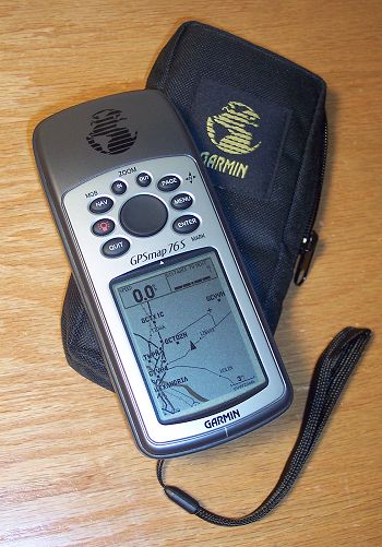
This is not the newest unit Garmin sells and is not the top of the line in handheld units (nor for that matter, is it the bottom of line, either). From what I can tell Garmin tends to introduce a basic design, then over the life of that design incrementally add features. For example, the 76 family includes the GPS 76, GPSMap 76, GPSMap 76S, GPSMap 76C, GPSMap 76CS, GPSMap 76Cx and GPSMap 76CSx. The line starts with the basic GPS 76, which has 1 MB of memory and no mapping. From there, you add maps ("GPSMap"), sensors ("S", compass and barometric altimeter), color screens ("C") and "expanded" features ("x") such as a more sensitive receiver and expandable card memory. The same pattern can be found in most of Garmin's products. And of course, the price naturally ramps up as features are added. For my uses, the GPSMap 76S so far seems to be about right.
For the terminally curious, the keys are labeled clockwise from lower left -
The Screens
Although by no means a complete review/description of the unit, here are a few details of my GPSMap 76S for those who've not seen one.
Splash and Disclaimer Pages
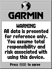
These three screens ("pages") appear in this order when the unit is powered up. The first two will eventually go away on their own (or via a button press), but the third requires an explicit acceptance (legal reasons, I suppose).
GPS Information Page
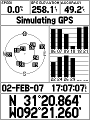
This shows the number of satellites it's currently using and their approximate locations on the celestial sphere, as well as a number of other fields. The other information displayed includes -
* These screen shots were taken with the receiver in simulation mode, rather than with an actual fix, since I was indoors and reception was intermittent. Also, simulator mode uses less battery power than full receiver mode.
Map Page
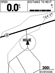
The Map Page shows, well, the map! If you buy MapSource (from Garmin), you can use it to load various specialized maps (as well as waypoints, routes, tracks, etc.) onto your receiver. Here, you can see the part of the eastern side of US Topo, specifically where I live. You can see the 164 foot elevation contour snaking across the map. Without a MapSource map, you'll see whatever basemap was installed on your receiver when you bought it (which should correspond to your part of the world).
The map page shows your current speed and distant to the next turn or waypoint by default, but the information appearing onscreen is configurable. On the map itself, there is a "vessel" (in nRoute jargon, i.e., the triangle) that indicates your position, and when moving, your basic heading. The "overzoom" prompt in the lower right corner indicates that the resolution of the display has exceeded the resolution of the map data, basically, so there is more more detail to be shown by zooming further in. Above it is a distance scale.
Compass Page
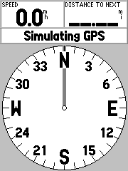
Although the GPSMap 76S includes a magnetic compass, it is functionally a bit different from the "GPS-powered" compass with which it shares this page. What does that mean? Well, the additional compass included in the 76S is an actual magnetic compass, while the GSP simulated compass computes your heading based on your movement. As a result, to get an accurate reading while standing still, you'll have to use the real compass. However, by switching the real compass off and using the GPS compass, you can sometime save up to a third of the battery drain. As a result, many people leave the compass turned off, turning it on only briefly to take a bearing. Holding the Page key down while on the compass page will turn the real compass off or on.
As with the other pages, the number of data fields is configurable, as well as the type of data they display.
Highway Page
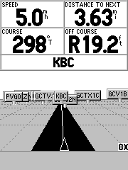
See those little "signs" off in the distance? They're waypoints, which are specific named locations saved on the receiver. In this (simulated) situation, I'm headed to the waypoint "KBC", which is (nearly) straight ahead and 3.63 miles distant. I'm currently making 5 miles per hour and my course heading is 298 degrees true. If you look closely at the "vessel" indicator, you can see it's a little to the right of the road's centerline. This is confirmed in the "OFF COURSE" data field, which shows me to be right of course by 19.2 feet.
The next waypoint is displayed in the field immediately above the highway display. Also, the current zoom is shown in the lower right corner.
Active Route / Goto Page
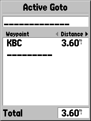
A route is a sequentially connected series of waypoints that define how to navigate from the start to the end of your trip (or some segment thereof). Since the 76S is not an "autorouting" receiver, I've not played with this very much. Think of it this way - Let's say you want to go from A to B to C, but in between and A and B there's a lake, and in between B and C there's a gorge. Obviously you don't want to (or even can't) walk a straight line from one waypoint to the next. Well, an autorouting unit will take the obstacles into account in insert more waypoints as necessary to navigate you around them. The final route might have waypoints A, A1, B, B1 and then finally C.
That's where this page comes into play - It will list all the waypoints in your route. It's kind of a status board. You can also read the distance to the next waypoint, or the distance of that leg of the route. So, why is this screen on my unit, when it doesn't autoroute? Well, if I recall my documentation correctly, I can manually define a route (either on the receiver via the keys, or by using MapSource on my PC) and it can be displayed here. Stay tuned for details.
One note - A route and a track, while related, are not the same thing. A route is a plan to be followed, while a track is the record of where you've actually been. You can also "trackback" by telling the receiver to direct you through a track, but in the reverse direction. This can be VERY handy to get you back to where you came from - Just clear the track log before you leave camp (or your car or whatever) and when you're ready to return, tell the receive to trackback. It will direct you, turn by turn, back to your starting point.
Plot Page
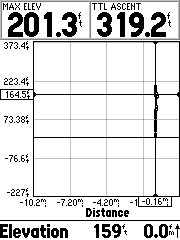
This page can graphically plot changes in altitude over distance and barometric pressure over time. I'm sorry I don't have a better screen shot... I recently cleared the track log and right now, it's cold, damp and dark outside (plus, Louisiana is awfully flat). In simulation mode, there's not a lot to show, but you can adjust the chart ranges to best display your graph, as well as tweak it in other ways. You can see the maximum elevation and total ascent data fields, as well as the current elevation and vertical speed.
The Main Menu
I specifically didn't make a screenshot of this, since it's all settings and there are LOTS of configuration pages. Suffice to say that the unit can be tweaked quite well!
Software
I'll mention this only briefly, since I'm far from knowledgable... There are myriad software package available, both specifically for Garmin units, as well as genericaly for all units. Here are some of the ones I've settled on (at the moment) --
Check out my links page for more.
The Case for Protection
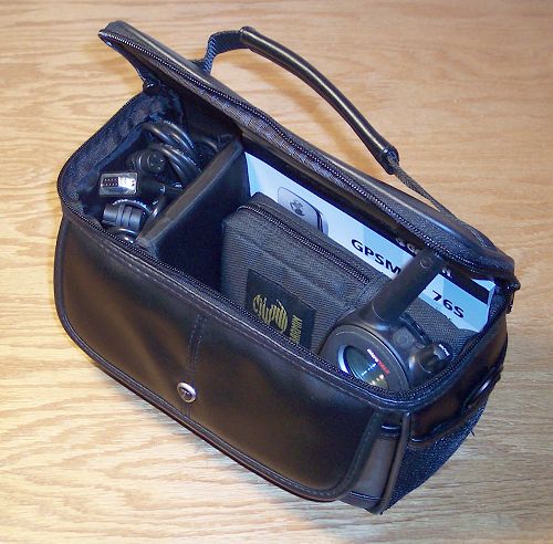
I bought a belt-case for my receiver, which I like. However, being the organizational (A.R.) person I am, I wanted a way to neatly carry everything together. I found this small camcorder case at Wal-Mart for about $15 and it does a nice job of holding what it needs to hold without being too large. I even have room for a couple of GMRS radios if need be. And, yes, there's a "real" compass in that front pocket, not to mention extra batteries in one side pocket, the manual, AC power supply, PC cable and whatever else I can cram into it. By the way - ALWAYS have a backup means of navigation available other than your GPS. The technology is wonderful, but like all technology, it's not immune to failure (can you say, "dead batteries"?) and you don't want to be left high and dry in the back country.
I started to buy a regular small "twin zipper" travel kit to serve as a case. It was about $10 cheaper than this case. A couple of minutes in thought proved how "penny-wise and pound-foolish" that would have been... I spend about $250 on the receiver, cables and such, but then balk at $15 to protect it? The five-dollar travel bag would have been cheaper. Cheaper - In more ways than one.
GeoCaching
Just a brief word about geocaching - The sport where You're the search engine.
A geocache (or simply cache) is just a small weatherproof container typically containing a logbook and possibly other small trinkets and inexpensive items. It's placed at a specific location, with the intent being that others will use their GPS receivers to find the cache. Once found, the logbook is signed and if desired, an item can be taken and a new item of roughly equal or greater value left in its place.
Probably the best place to start learning about geocaching is at geocaching.com. There is a FAQ, lists of (thousands? of) caches and links to other geocaching and GPS-related websites. There's an entire community that has developed around geocaching, and you can learn all about it there.