|
Last
Updated 9:25am on 12/22/24
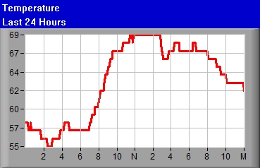
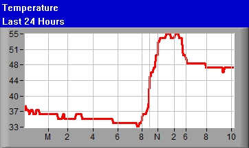
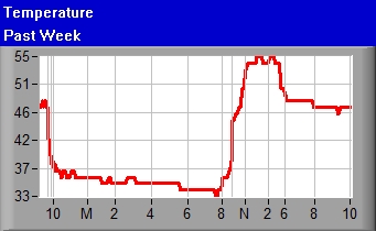
Temperature 33.0°F
(Airport mtr004KEWN°F)
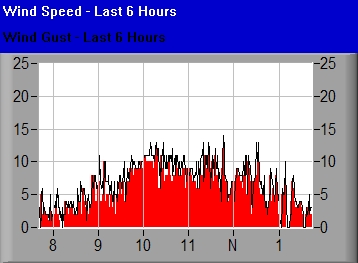
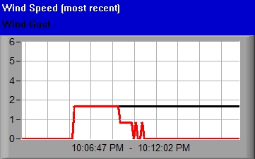
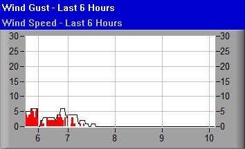
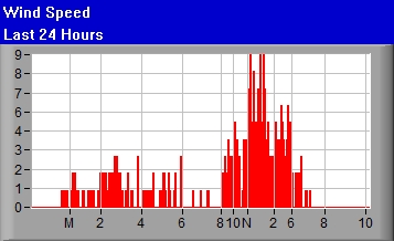
Wind Speed Currently
13Mph NNE
Average over last minute


Moderate Breeze
mtr014KEWN
|
Temperature 33.0°F
(Airport mtr004KEWN°F)
|
|
|
|
|
|
|
|
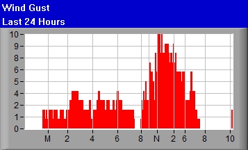
Wind Gust 13mph
|
|
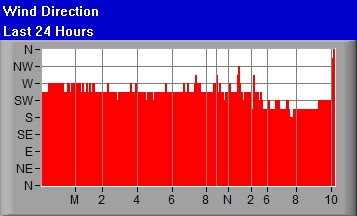
Direction NNE
|
|
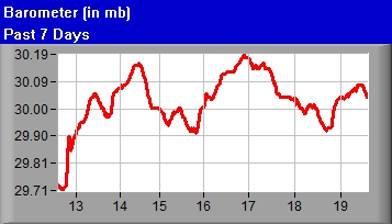
Barometer 1032.21
|
|
Wind Chill 23.6 
|
|
|
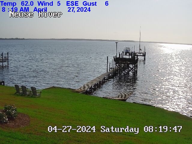
Viewing mouth of Upper Broad Creek, just below Northwest Creek and
Fairfield Harbour, taken South of Johnson Point facing ENE

Viewing Minnesott - Cherry Branch in distance, taken South of Johnson Point facing
South
East
Refresh
New Bern Area Weather Forecast
Weather Synopsis
Expires:202412230115;;195541
FZUS52 KMHX 221234
CWFMHX

Coastal Waters Forecast for North Carolina
National Weather Service Newport/Morehead City NC
734 AM EST Sun Dec 22 2024

From S of Currituck Beach Light to N of Surf City NC out 20 NM,
including the Albemarle and Pamlico Sounds and the Monitor
National Marine Sanctuary


AMZ100-230115-
734 AM EST Sun Dec 22 2024

.Synopsis for Eastern North Carolina coastal waters...
Cold and dry conditions as high pressure dominates. Elevated
winds and seas this morning gradually wane through the day.
Chances of rain pick up Tuesday as a coastal trough sets up
offshore.


$$
|
Neuse and Bay River Marine Forecast
Expires:202412230115;;195547
FZUS52 KMHX 221234
CWFMHX

Coastal Waters Forecast for North Carolina
National Weather Service Newport/Morehead City NC
734 AM EST Sun Dec 22 2024

From S of Currituck Beach Light to N of Surf City NC out 20 NM,
including the Albemarle and Pamlico Sounds and the Monitor
National Marine Sanctuary


AMZ137-230115-
Neuse and Bay Rivers-
734 AM EST Sun Dec 22 2024

.TODAY...N winds 10 to 15 kt. Waves a moderate chop.
.TONIGHT...NE winds 10 to 15 kt. Waves a moderate chop.
.MON...NE winds 10 to 15 kt, diminishing to 5 to 10 kt in the
afternoon. Waves a moderate chop, diminishing to light chop in
the afternoon.
.MON NIGHT...NE winds 5 to 10 kt, becoming N after midnight.
Waves light chop, diminishing to flat after midnight. A slight
chance of rain after midnight.
.TUE...N winds 5 to 10 kt. Waves light chop. A chance of rain.
.TUE NIGHT...N winds 5 to 10 kt, increasing to 10 to 15 kt after
midnight. Waves light chop, increasing to a moderate chop after
midnight.
.WED...N winds 10 to 15 kt. Waves a moderate chop.
.WED NIGHT...N winds 10 to 15 kt. Waves a moderate chop. A chance
of showers in the evening.
.THU...N winds 10 to 15 kt. Waves a moderate chop.
.THU NIGHT...NE winds 10 to 15 kt. Waves a moderate chop.

$$
|
Pamlico Sound Marine Forecast
Expires:202412230115;;195545
FZUS52 KMHX 221234
CWFMHX

Coastal Waters Forecast for North Carolina
National Weather Service Newport/Morehead City NC
734 AM EST Sun Dec 22 2024

From S of Currituck Beach Light to N of Surf City NC out 20 NM,
including the Albemarle and Pamlico Sounds and the Monitor
National Marine Sanctuary


AMZ135-230115-
Pamlico Sound-
734 AM EST Sun Dec 22 2024

...SMALL CRAFT ADVISORY IN EFFECT UNTIL 11 AM EST THIS MORNING...

.TODAY...N winds 15 to 20 kt. Gusts up to 25 kt this morning.
Waves 2 to 3 ft.
.TONIGHT...N winds 10 to 15 kt. Waves around 2 ft.
.MON...NE winds 10 to 15 kt. Waves around 2 ft in the morning,
then 1 ft.
.MON NIGHT...NE winds 5 to 10 kt, becoming NW after midnight.
Waves 1 ft or less. A chance of rain after midnight.
.TUE...N winds 5 to 10 kt, increasing to 10 to 15 kt in the
afternoon. Waves 1 ft or less, then around 2 ft in the afternoon.
A chance of rain.
.TUE NIGHT...N winds 10 to 15 kt. Waves around 2 ft. A chance of
rain in the evening.
.WED...N winds around 15 kt. Waves around 2 ft.
.WED NIGHT...N winds 10 to 15 kt. Waves around 2 ft. A chance of
showers in the evening.
.THU...N winds around 15 kt. Waves around 2 ft.
.THU NIGHT...NE winds around 15 kt. Waves around 2 ft.

$$
|

https://www.neuseweather.com/windspeed.jpg